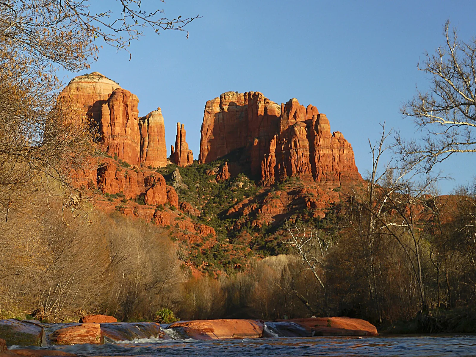
Sedona looks like it has always been here — the red buttes, the juniper, the creek running green through the middle of it all. But the town itself is young. The post office dates to 1902, the city to 1988, and everything in between is a compressed version of the whole Western story: ancient farmers, forced removals, homesteaders hauling apples over a wagon road, movie crews, artists, and finally millions of visitors a year. This guide walks through that story in order, from the rocks themselves to the town you’ll drive into, with pointers to the places where you can still see each chapter firsthand.
Why the rocks are red
Start about 280 million years ago, in the Permian period. What’s now Sedona sat near the coastline of the supercontinent Pangea, covered by shifting coastal dune fields, tidal flats, and shallow seas. Sand piled up in those environments for millions of years and hardened into a layer of sandstone 800 to 1,000 feet thick. Geologists call it the Schnebly Hill Formation, and it’s the layer that forms most of the famous shapes around town — Cathedral Rock, Bell Rock, Coffee Pot Rock, the walls above Uptown.
The red comes from hematite, an iron-oxide mineral — rust, essentially. A film of it coats nearly every sand grain in the formation, and the coating is so thin that only a trace amount of iron is needed to produce the deep red-orange color. The formation actually has structure inside it: a lower Bell Rock Member, an upper Sycamore Pass Member, and between them a thin gray limestone band called the Fort Apache Member, left behind when the sea briefly moved back in.
Everything since has been subtraction. Uplift of the Colorado Plateau raised the whole stack thousands of feet, and erosion — mostly water, working patiently — carved away the softer rock and left the buttes and spires standing. Oak Creek is still doing that work today. When you drive down Oak Creek Canyon from Flagstaff, you’re descending through the layer cake, and when you bounce down Schnebly Hill Road you’re on the formation that carries the town founder’s name.
That’s the whole geology lesson in three paragraphs: old sand, a little rust, and a lot of erosion. Everything else in this guide happened in the last few thousand years — a rounding error by comparison.
The first people: the Sinagua
People have passed through this country for thousands of years. The oldest rock art at Palatki, west of Sedona, includes abstract pictographs from the Archaic period estimated at 3,000 to 6,000 years old — older than most of the ruins anywhere in the Southwest that visitors can walk up to.
The culture most associated with Sedona, though, is the Sinagua. Archaeologists gave them the name — Spanish for “without water” — for their knack for farming a dry land. They grew corn, beans, and squash in the Verde Valley, traded across the region, and around 1150 CE began building the cliff dwellings that survive today. The two largest in the red rock country are Palatki and Honanki, tucked into south-facing alcoves in the cliffs northwest of Sedona and occupied from roughly 1150 to 1300 CE. Both sites are managed by the Coconino National Forest and open to visitors — Palatki requires a reservation — and both are covered in our Palatki and Honanki guide.
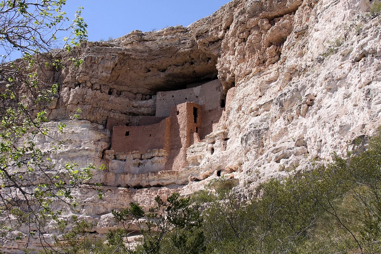
The most dramatic Sinagua building of all is 45 minutes south of Sedona: Montezuma Castle, a five-story, 20-room dwelling set high in a limestone cliff above Beaver Creek, built between roughly 1100 and 1400. Early settlers assumed the Aztec emperor Montezuma had something to do with it — he didn’t, and never came within a thousand miles — but the name stuck. On December 8, 1906, President Theodore Roosevelt made it one of the first four national monuments in the country under the brand-new Antiquities Act. It’s an easy half-day trip; our Montezuma Castle guide has the details.
By about 1400 the Sinagua had moved on from the Verde Valley. They didn’t vanish — the Hopi count them among their ancestors, and Hopi clans still maintain ties to these sites. The dwellings they left behind sat quiet in the cliffs for centuries.
The Yavapai, the Apache, and the removal of 1875
After the Sinagua left, the Yavapai and later the Tonto Apache made this country home. They lived across the Verde Valley and the red rock canyons for roughly 400 years, hunting, gathering, farming along the creeks, and adding their own rock art to the panels at Honanki and Palatki — some of it painted directly alongside images a thousand years older.
The end of that era came fast and brutally. After gold strikes brought prospectors and settlers into central Arizona in the 1860s, the federal government promised the Yavapai and Apache a 900-square-mile reservation along the Verde River. The people settled there, dug irrigation ditches, and raised successful crops. Then the promise was revoked. In February 1875, the U.S. Army forced roughly 1,400 Yavapai and Apache men, women, and children on a winter march of about 180 miles over rough mountain country to the San Carlos Reservation in southeastern Arizona. Hundreds died on the way and in the deportations that followed. The Yavapai-Apache Nation commemorates the event every year as Exodus Day.
A generation later, some families made their way back to the Verde Valley, many working in the copper smelters and on ranches. Their descendants form today’s Yavapai-Apache Nation, headquartered in Camp Verde, about 30 minutes from Sedona. It’s worth holding this chapter in mind when you hear the phrase “first settler” in Sedona history — the land was nobody’s blank slate. The first Anglo homesteader arrived the year after the removal.
Homesteaders on Oak Creek: 1876 to 1902
That homesteader was John James “Jim” Thompson, who in 1876 settled a spot partway up Oak Creek Canyon where the departed Apache had tended irrigated garden plots of corn and squash. Thompson called the place Indian Gardens — the name it still carries, and you’ll drive right past it on the canyon road north of Uptown. He built a log cabin, farmed the old garden ground, and stayed until his death in 1917. A historical marker stands at the site today, and the West Fork trail and the rest of the canyon he settled remain the prettiest walking country in the region.
Other families followed through the 1880s and 1890s — the Purtymuns, the Jameses, the Schuermans, who planted wine grapes along lower Oak Creek near today’s Red Rock Crossing. Growth was slow. By 1900, only about 15 homesteading families lived in what’s now the Sedona area. There was no town, no store, no post office. Mail and supplies meant a multi-day wagon trip to Flagstaff, 2,000 feet up on the Mogollon Rim, or a long haul down the valley to Jerome and Cottonwood.
What these families had going for them was water and climate. Oak Creek ran year-round, the growing season at 4,350 feet was long enough for fruit, and the canyon walls sheltered the orchards. Apples and peaches from Oak Creek Canyon became the area’s cash crop and stayed that way for half a century.
T.C. Schnebly, a post office, and a name: 1902
Around the turn of the century, an ambitious young Missourian named Theodore Carlton “T.C.” Schnebly arrived from Gorin, Missouri, with his wife and children. His brother Ellsworth had come to Arizona for his health and talked the family into joining him. T.C. bought land along Oak Creek near present-day Tlaquepaque and hauled lumber down from Flagstaff to build a large two-story house — 11 rooms, big enough that it doubled as the area’s first hotel and general store.
Schnebly saw that the scattered families needed regular mail service, so in 1902 he applied to Washington to open a post office. On the application he proposed two names: Oak Creek Crossing and Schnebly Station. Both came back rejected — the Postmaster General of the day favored short, one-word names that fit a postmark. Ellsworth offered the fix that made history: name it after your wife.
His wife was Sedona Arabella Miller Schnebly, born February 24, 1877, in Gorin, Missouri. Her name wasn’t Spanish and wasn’t Native American — her mother, Amanda Miller, simply made it up because she thought it sounded pretty. Postal officials approved it, and on June 26, 1902, the Sedona post office opened for business in the back of the Schnebly home, with T.C. handling the mail.
Sedona Schnebly herself lived a hard frontier life. The family left for Colorado in 1905 after their young daughter Pearl died in a riding accident, then returned to Sedona around 1930 and stayed. Sedona died on November 13, 1950, and she and T.C. are buried at Cooks Cedar Glade Cemetery off Airport Road, a few minutes from the Airport Mesa loop. She was, by every account, generous and devout — and she remains one of the few American towns’ namesakes who actually lived in the town for decades.
One more Schnebly legacy: the road. A rough track over the rim to Flagstaff had been scratched out along an old cattle trail in the 1890s, and in 1902 Coconino County paid $600 — laborers earned a dollar for a 12-hour day — to improve it. T.C. used it to haul his produce north and merchandise south, cutting the Flagstaff round trip from four days to two, and locals started calling it Schnebly Hill Road. Today it’s one of the most popular rough-road drives in Arizona; see our Schnebly Hill Road guide before you attempt it in a rental sedan (short version: don’t).
The orchard years
For the first half of the 20th century, Sedona was a farm town — and a small one. The canyon and creekside homesteads produced apples and peaches that wagons, and later trucks, carried to Flagstaff, Jerome, and beyond.
The best-preserved piece of that era belonged to Walter and Ruth Jordan, who established an apple orchard in 1930 on a ranch that eventually covered about 175 acres — most of what is now Uptown Sedona and the surrounding neighborhoods. Their red rock farmhouse, tractor shed, and fruit-packing shed still stand at 735 Jordan Road, all three listed on the National Register of Historic Places. In 1998, fulfilling Ruth Jordan’s wish that the farm be preserved, the property opened as the Sedona Heritage Museum, and it remains the single best place in town to get the whole story told in one stop.
Commercial orcharding faded in the 1970s and 80s. Rising land values, the 1970s gas crisis that made shipping fruit uneconomical, and the passing of the second generation of farm families all pushed the same direction: orchard land was worth more as real estate. The apples gave way to galleries, motels, and subdivisions. But the Jordan farm’s apple-sorting machine still works, and the museum fires it up for demonstrations.
Hollywood in the red rocks
In 1923, a Paramount crew came to Oak Creek Canyon to film The Call of the Canyon, a silent adaptation of the Zane Grey novel Grey had set right here. Directed by Victor Fleming — who went on to direct Gone with the Wind and The Wizard of Oz — and shot near Mayhew’s Lodge in the canyon, it was the first movie ever filmed in Sedona. (The film was lost for decades until a print turned up in Russia’s state film archive; a copy was presented to the Library of Congress in 2010.)
That picture opened the floodgates. Over the next four decades, close to 100 feature films used Sedona’s red rocks as a backdrop. John Wayne arrived in 1945 to produce Angel and the Badman, and the town built its first permanent movie sets. Through the 1950s, Sedona stood in for practically every corner of the mythical West in pictures like Broken Arrow and Johnny Guitar. For a village of a few hundred people, film crews were a serious industry — locals worked as extras, wranglers, and carpenters between harvests.
We keep this section short on purpose, because the movie era gets two full deep dives on this site: the westerns filmed in Sedona covers the films and their stories, and Sedona film locations maps the actual spots you can stand on today. If old westerns are your thing, read both — several locations are on hiking trails you’d be walking anyway.
The Chapel of the Holy Cross: 1956
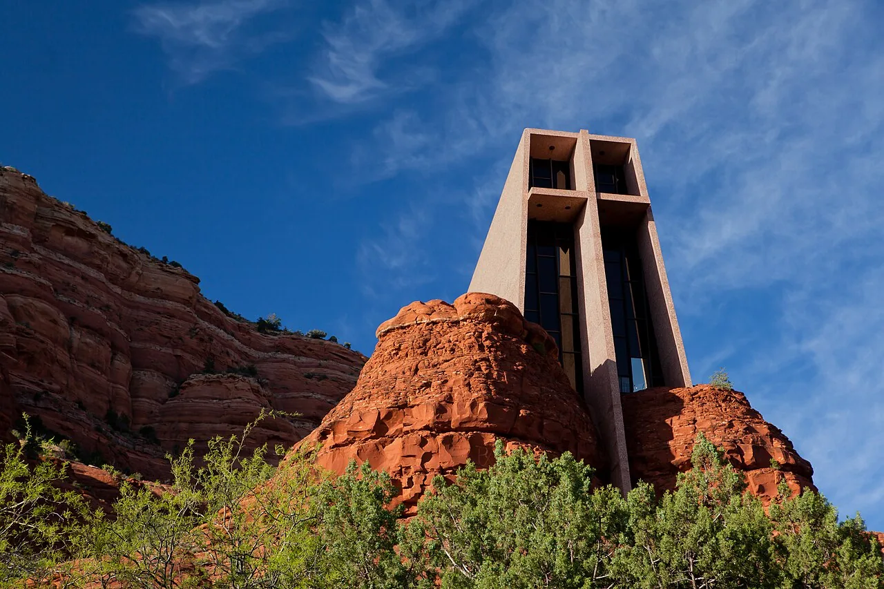
Sedona’s most famous building came from a sculptor’s decades-long obsession. Marguerite Brunswig Staude, an artist and rancher, had been struck in 1932 by the newly built Empire State Building and resolved to build a modern church — one she first tried to build in Budapest, until World War II ended that plan. In the early 1950s she turned to the red rock buttes south of Sedona, on Coconino National Forest land; Senator Barry Goldwater helped secure the special-use permit.
The Chapel of the Holy Cross was built from 1954 to 1956, designed by August K. Strotz with project architect Richard Hein of the firm Anshen & Allen, and constructed in 18 months for about $300,000. Crews moved some 25 tons of rock without dynamite to seat the structure into the butte. The result — a concrete wedge rising from the rock with a 90-foot cross forming its face — won an American Institute of Architects Award of Honor in 1957 and has been photographed roughly a billion times since.
The chapel is a working Roman Catholic chapel, free to visit, and one of the few pieces of Sedona history that is also a first-tier sight in its own right. Our Chapel of the Holy Cross guide covers parking (the real challenge), hours, and the best light for photos.
Vortexes, incorporation, and the tourism town: 1980 to now
Through the 1960s and 70s, Sedona grew slowly as a retirement, ranching, and arts community — galleries took root, and the Tlaquepaque arts village rose beside Oak Creek on land near the old Schnebly homestead. Then the 1980s changed the town’s identity twice in one decade.
First came the New Age. Around 1980, an author and psychic named Page Bryant identified what she called “vortex” sites around Sedona — places she described as centers of spiritual energy — and the idea caught on far beyond anything she could have predicted. In August 1987, the worldwide Harmonic Convergence event named Sedona one of its sacred sites, and thousands of believers converged on Bell Rock and the other formations to meditate. Crystal shops, aura photographers, and spiritual retreats followed, and they never left. Whatever you make of the metaphysics, the vortex map is now a permanent layer of Sedona’s geography; our vortex guide explains the four main sites and how to visit them with an open mind and good hiking shoes.
Second, and less mystically, Sedona finally became a city. After 86 years as an unincorporated community split between two counties, residents voted to incorporate, and the City of Sedona was born in January 1988. The city line still straddles the Yavapai-Coconino county boundary — Uptown and the Chapel area sit in Coconino County, while West Sedona sits in Yavapai County — a quirk left over from the days when the county line down Oak Creek mattered more than the town did.
Since then the story has been tourism, full time. Sedona today has a resident population of around 10,000 and hosts an estimated three million visitors a year, drawn by the same rocks that drew the movie crews and the same creek that drew the homesteaders. Uptown — the old Jordan ranch — is the visitor core of shops and tour outfits. West Sedona, strung along State Route 89A, is where the town actually lives: the grocery stores, the schools, most of the restaurants locals eat at, and the quiet residential streets with red rock views in every direction. It’s also where Sedona Pickler sits, which means you stay in the real neighborhood and drive minutes, not miles, to the trailheads and the history.
Where to touch the history today
Sedona’s past isn’t sealed behind glass. Almost every chapter above has a place you can stand:
| Era | Place | Notes |
|---|---|---|
| Geology | Schnebly Hill Road, Oak Creek Canyon | The rock layers, up close; high-clearance vehicle for the road |
| Archaic and Sinagua | Palatki and Honanki | Cliff dwellings and 6,000 years of rock art; Palatki takes reservations |
| Sinagua | Montezuma Castle | Five-story cliff dwelling, 45 minutes south; NPS site, small entry fee |
| Homestead era | Indian Gardens, Oak Creek Canyon | Historical marker at Thompson’s 1876 settlement; market and cafe nearby |
| Orchard era | Sedona Heritage Museum, 735 Jordan Road | The Jordan farm, movie exhibit, Schnebly story; modest admission, confirm current hours |
| Mining era (regional) | Jerome | Copper boomtown turned art town, 45 minutes away |
| Movie era | Film location sites around town | See our film-locations guide for a map |
| 1956 | Chapel of the Holy Cross | Free, open daily |
Three of those deserve a plan rather than a drive-by. The Sedona Heritage Museum rewards an unhurried hour — the volunteer docents are often longtime residents with firsthand stories. Palatki and Honanki put you inside rooms built 900 years ago, a short scramble from your car. And Jerome — a copper town where the first claims were filed in 1876, the same year Thompson settled Indian Gardens — boomed to more than 10,000 people in the 1920s, emptied to fewer than 100 when the mine closed in 1953, and was reborn as a National Historic Landmark (1967) full of galleries and saloons clinging to the side of Cleopatra Hill. It makes an easy half-day loop with Old Town Cottonwood.
A practical note for planning: the historical sites are spread across the Verde Valley, and none of them take long individually. A single relaxed day can cover Montezuma Castle in the morning, Jerome in the afternoon, and dinner back in West Sedona. Add the museum and the cliff dwellings on a second morning and you’ll have seen more of Sedona’s actual history than most visitors who’ve come here for decades.
And then the evening is yours. One of the quiet pleasures of learning a place’s history is looking at the same rocks afterward and seeing more in them — the Permian dunes in the cross-bedding, the Sinagua alcoves in the shadows, the movie frames in the skyline. Watch the sunset paint the hematite red from one of the best sunset spots, then go play a few games on the indoor court where the only thing historic is your backhand.
Frequently asked questions
How did Sedona, Arizona get its name?
Is Sedona a Native American or Spanish name?
Who lived in Sedona before settlers arrived?
Why are Sedona's rocks red?
When did Sedona become a city?
What old movies were filmed in Sedona?
Where can I see Sedona's history in person?
Stay where you can rally any season
Sedona Pickler is a private West Sedona vacation home with its own indoor, climate-controlled pickleball court — a short drive from the trailheads, viewpoints and restaurants in this Sedona guide. Play at sunrise or after dark, in any weather.
Check dates & book


